Africa is the huge continent situated to the south of Europe. It is the second largest continent in the world, and has the second biggest population out of any continent in the world. Approximately 14.72% of the world`s population is in Africa. In specific numerical terms, that means around one billion people, similar to the population of India or China.
Africa is usually said to have 55 countries, which includes the disputed territory of Western Sahara (which is internationally recognized but is occupied by Morrocco). 48 of these countries are located on the mainland of the African contient, while 6 are island nations. It also includes the very new country of Southern Sudan.
The African Union includes 54 of the 55 internationally recognized African countries, with Morocco refusing to join because of the AU`s inclusion of Western Sahara.
There are other de facto nations with their own independently operating governments in Africa, specifically in the place we commonly know as Somalia. Only one government is internationally recognized in Somalia, but 2 de facto nations of Somaliland and Puntland exist in different areas of the country. The only thing that keeps Somaliland and Puntland from being on the political map of Africa is a lack of recognition by other countries. In practical terms, they are independent. This was the situation with South Sudan until its recent independence.
Here are some political Africa maps for your reference.

Update: Here is a 2012 political map of Africa that includes the world`s newest country: Southern Sudan.

Africa is usually said to have 55 countries, which includes the disputed territory of Western Sahara (which is internationally recognized but is occupied by Morrocco). 48 of these countries are located on the mainland of the African contient, while 6 are island nations. It also includes the very new country of Southern Sudan.
The African Union includes 54 of the 55 internationally recognized African countries, with Morocco refusing to join because of the AU`s inclusion of Western Sahara.
There are other de facto nations with their own independently operating governments in Africa, specifically in the place we commonly know as Somalia. Only one government is internationally recognized in Somalia, but 2 de facto nations of Somaliland and Puntland exist in different areas of the country. The only thing that keeps Somaliland and Puntland from being on the political map of Africa is a lack of recognition by other countries. In practical terms, they are independent. This was the situation with South Sudan until its recent independence.
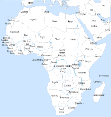
Here are some political Africa maps for your reference.


Update: Here is a 2012 political map of Africa that includes the world`s newest country: Southern Sudan.


0 Comments